Sunday, December 20, 2009
Google Map of Thai Real Estate
ReThai
ReThai uses the Google Maps API to show properties for sale or rent in Thailand. Anyone can advertise a property listing on the map for free by registering with the site. Real estate agents can even add a logo and business details to their properties added to ReThai.
It is possible to search for properties on the map by price range, property type and location. Clicking on a property's map marker opens an information window with information about the listing and direct contact details of the property's owner.
Friday, December 18, 2009
Google Maps Shows You the Way to Your Swine Flu Vaccine [Maps]
By Jesus Diaz on Swine flu
The Pandemic That Was Going to Kill Us All But Didn't is still alive, lurking to take you in a one-way trip across the Styx. Or a two-way trip to Snotland. Google Maps points the way to the nearest vaccine.
The search engine has collaborated with the U.S. Department for Health and Human Services to add a Google Maps' service that will locate the nearest seasonal and H1N1 flu vaccine programs. Just go to this site and enter your city or postal code. Google says that the project has just started, so there are still locations with no information:
At the moment we have data for locations of flu vaccine directly from 20 states and counting. We are also continuing to add information from chain pharmacies and other providers in all 50 states; today, you'll find results from chains such as Walgreens, CVS and PDX participants, such as Kmart, Duane Reade, WinnDixie and Giant Eagle.
After reading about the many problems with the vaccine in countries like Sweden—where they have top notch healthcare—I think I will pass on this round, thank you very much.
Saturday, September 5, 2009
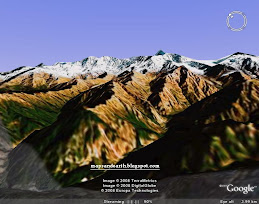
Mt. Shasta Bunny Flat Trail 7100ft to 9000ft: 5.4 mile hike
Monday, August 31, 2009
Giant Gulliver from Google Earth, Hunters Hall Park, Craigmillar, Scotland
View Larger Map
Wednesday, July 22, 2009
Explore the Moon in Google Earth
"Each of the Apollo landing missions is chronicled in detail through pictures and stories. We've even embedded video footage from Spacecraft Films that covers the most well-known moments on the surface. There are also immersive lunar surface panoramas, composed of photos taken by the astronauts themselves, presented for the first time in a 3D Street View style interface," explains Google.
you need a recent version of Google Earth
Saturday, July 18, 2009
The Google Maps alphabet UK: an A to Z of the British Isles-D-
The Google Maps alphabet UK: an A to Z of the British Isles-C-
The Google Maps alphabet UK: an A to Z of the British Isles-B-
The letter B, from Weston on the Green, Oxfordshire
The Google Maps alphabet UK: an A to Z of the British Isles
Sunday, July 12, 2009
Simultaneous Searches in Google Maps
Friday, April 10, 2009
Google becomes more local
Google maps likes to make search as easy as it can, so they just finished the worldwide rollout of local search results on a map, which will now appear even when you don't type in a location. When you search on Google and will guess where you are and show results near you.
How Google maps know your location?, they match your IP address to a broad geographical location. You can also specify your likely location using the "Change location" link on the top right corner, above the map. Google maps try to make our guesses as good as they can be so that whether you're shopping for [sporting goods] or [flowers], or looking for your [bank], or the [post office], you can just say what you want, and Google maps try to find it right where you are. You can also search for specific stores or street addresses near you, like [cornelia st cafe] in New York, for example.
Or [111 8th ave] in New York.
Thursday, March 26, 2009
Find Custom Maps-president birth places
Until recently, Google Maps only pointed to items from custom maps and geo-feeds, but now you can find the maps in the list of results. For example, a search for [president birth places] returns a map that shows where each president of the US was born.
You can restrict your search to custom maps and GeoRSS feeds by clicking on "show search options" and selecting "related maps". The index includes the public maps created from the "My Maps" interface.
Google Maps tries to go beyond basic queries like "pizza in ny" by using the web index. Google LatLong gives some examples of complicated queries that return useful results: bridge collapse in MN, falafel carts in nyc. Unfortunately, Google Maps has a very basic understanding of queries and can't always differentiate a general query like "places to go in London" from a search that asks for directions.
Monday, March 23, 2009
Google Street View for UK and Netherlands
Google Maps added street view imagery for many major cities in the United Kingdom and the Netherlands. London, Liverpool, Birmingham, Glasgow, Belfast, Amsterdam and Rotterdam are some of the cities added to Google Street View.
Saturday, March 21, 2009
3D Ocean Models Tour
This KML is a simple placemark tour of the models created by the SketchUp team in Boulder, Colorado for the launch of the new Ocean feature of Google Earth 5.0. The models are currently in the 3D Buildings layer in Google Earth 5. They can also be viewed in the 3D Warehouse in the 'Google Earth - Ocean Layer' collection - http://sketchup.google.com/3dwarehouse/
Current (30 day) Arctic Sea Ice Concentrations and Extents
Providing a near real-time examination of current sea ice concentration conditions in the Arctic, this KML allows you to view the previous 30 days sea ice concentration, gathered from satellite data up until the present day. Updated daily, this KML which is presented as a series of animated overlays, can provide useful data to those studying climate change, in particular the potential for sea levels rising. To view the animation, simply open the KML file and press the play button located in the top section of the image viewer. Note: It is likely that you will need to allow the animation to run through once or twice to enable the image overlays to load fully.
Friday, February 27, 2009
Google Maps Adds User Photos To Street View
Google has added Panoramio photos to StreetView images.
Google’s image-matching algorithms will analyze them at some point to see if they are also a good match for a Street View location.
Google has offered images on Maps for some time, but not directly integrated into StreetView like this.
A thumbnail appears in the upper right of the StreetView image (see below). Clicking it opens a new view of the location with a horizontal scrolling bar of images. Users can click any of the images to enlarge. Google is implying it will only use a limited number of high-quality images for any location.
Here’s an example where the new user images do exist, for the Paris monument Arc de Triomphe:
Tuesday, February 10, 2009
Amazing mashup software of Craigslist and Googlemaps. AMAZING
Trace what happen on craigslist Using Google Maps
The Ultimate Guide To Buying & Selling On Craigslist. Dont Let Anyone Tell You There Is No Secret To Buying And Selling On Craigs List...
Friday, February 6, 2009
Find Your Followers on Twitter Using Google Earth
- or Do you have a brick and mortar business? Connect with your local clientele by using TwitterMap.com or TwitterLocal.net. These sites will show you all the Twitter updates happening in any given geographic area. Sign into your Twitter account and enter "L: city, state" and then visit TwitterMap or TwitterLocal to find "Twits" near you.
- Looking to hire employees? Send out a Tweet with what you're looking for. Followers who aren't necessarily in your geographic location might still know someone who is, and they'll re-Tweet the message for you.
- Build buzz for a future event. Having a blowout sale in two weeks? Let everyone know on Twitter. One person in your area with lots of followers has the potential to reach thousands of people, tens of thousands even.
- Looking for new ideas? Reach a broad range of like-minded businesses and use Twitter as a brainstorming platform.
- Building links to a small business Web site? Follow people who can help you out, engage in the community and when they call for help/suggestions, offer yours.
Monday, February 2, 2009
Google Street View Driver Hits Deer
One of those hiccups occurred recently as one of the drivers collided with a deer (which apparently lived and left the scene). Pictures of this made there way to Street View (you can see them here), and Google is now reporting that they have been pulled due to user requests.
Google uses a blog post about this to share some driving tips. It is also a good reason to look at how to report an inappropriate Street View image. To do this, simply:
1. Locate the image.
2. Click Report a concern in the bottom left corner. A new window will open.
3. Complete the form, and click Submit.
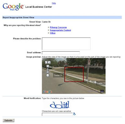
Once you do this, they will review your request. This doesn't necessarily mean that they will honor that request, but if more people complain about it, I would imagine they'll be more likely to do so. I find it hard to believe that there aren't pictures of dead animals littered throughout street view, however, considering how often I see them along the roads while driving.